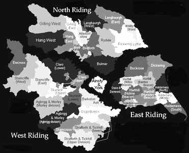
Wapentakes and Ridings
 A wapentake was a sub-division of a Riding, equivalent to the southern counties' Hundred and became obsolete around the year 1900.
The West Riding separated from the North Riding at Boroughbridge by the River Tutt, was divided into three parts:
- Northern part: Skipton, Keighley, Shipley, Sowerby, and Elland
- Eastern part: Ripon, Otley, Barkston Ash, Osgoldcross, Pudsey, and Spen Valley
- Southern part: Batley, Normanton, Colne Valley, Holmfirth, Barnsley, Hallamshire, Rotherham, and Doncaster
WEST RIDING - Agbrigg & Morley (Bradford, Dewsbury, Halifax, Huddersfield, Leeds suburbs, Wakefield); Barkston Ash (Selby, Tadcaster); Claro (Ripon, Knaresborough); Ewcross (Dent, Ingleton, Sedbergh); Osgoldcross (Pontefract, Goole, Snaith); Skyrack (Leeds); Staincliffe (Keighley, Settle, Skipton, Stainburn); Staincross (Barnsley); Strafforth and Tickhill (Doncaster, Rotherham, Sheffield).
Strafforth and Tickhill
Parishes with Area in acres
- Adwick-le-Street 2938
- Adwick-upon-Dearne 1142
- Arksey 5133
- Armthorpe 2923
- Aston 3329
- Barnbrough 2125
- Barnby Dun 4179
- Blyth ( part) 3039
- Bolton-upon-Dearne 2323
- Braithwell 2962
- Brodsworth 3120
- Cantley 5590
- Clayton 1589
- Conisbrough 4558
- Crowle 1281
- Darfield ( part) 9047
- Dinnington 709
- Doncaster 8843
- Ecclesfield 49616
- Edlington 1757
- Finningley 3076
- Fishlake 8190
- Handsworth 3637 (Details on Treeton Website)
- Harthill 3565
- Hatfield 7423
- Hickleton 1060
- High Melton
- Hooton Pagnell 2628
- Hooton Roberts 1056
- Kirk Sandal 1637
- Laughton-en-le-Morthen 17386
- Maltby 4645
- Mare 1820
- Melton-on-the-Hill 1525
- Mexborough 2366
- Ravenfield 1235
- Rawmarsh 2578
- Rossington 3051
- Rotherham 13585
- Sheffield 19650
- South Kirby (part) 238
- Sprotborough 3966
- Stainton 2857
- Thorne 12408
- Thrybergh 1707
- Thurnscoe 1672
- Tickhill 6778
- Todwick 1807
- Treeton 3363
- Wadworth 3133
- Wallingwells 351
- Warmsworth 1074
- Wath-upon-Dearne 11045
- Whiston 3189
- Wickersley 1273
